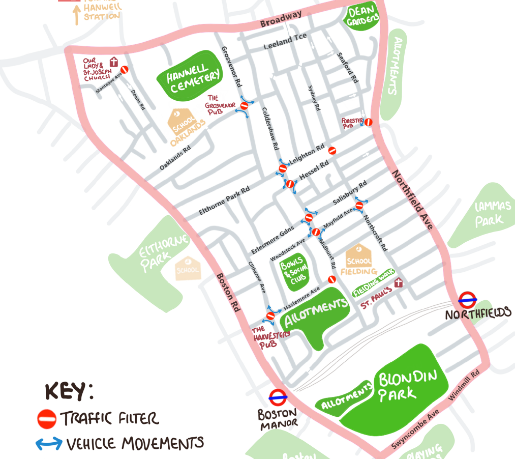
This is the map for the Council’s Low Traffic neighbourhood area south of The Broadway. Here’s a link to our story about this.
The Council’s Low Traffic Neighbourhood (LTN) plans are causing considerable concern amongst some of the residents in the affected areas. The Ealing Low Traffic Neighbourhood Action Group has been set up and their Facebook page is here.
Much of the concern centres around the disruption the LTNs will bring for local driving by pushing traffic off local distributor roads and on to quieter residential roads along with the impact on businesses , emergency services and deliveries. An online petition has been set up for people wanting the Council to have a consultation with residents before any action is taken. To date over 3,250 people have signed it. As it stands, the consultation will take place during the six months from installation of the LTNs.
Such a stupid idea, whoever done this needs sacking for wasting all of our money, and making more pollution.
I have published your map and comments on our website http://www.westealingbc.co.uk. I trust this is OK. A lot of our Members will not yet be aware of this ridiculous scheme.
hi i am a ocado driver and would to say how disgusting ealing council are for blocking roads just to do delivery’s is just made hard you dont think about people that are not from the area then driver getting stuck in roads because they cant drive though them it just a money making thing banned cyclist for ones
The restrictions in the name of LTNs are designed to make the life of citizens difficult. Quoting from the Ealing council website page (Key facts on low traffic neighborhoods), “it makes the journeys for those that were using the street as a cut through, more difficult.”. This will push the traffic on the main roads and create traffic snarls and long tail backs.
The scheme should be abandoned immediately as traffic forced to take long routes around the blocking points will create longer journeys and more pollutions.
With the schools starting in September , this ill conceived scheme will certainly cause hardship to parents, students and also the business around Ealing.
I have a business that requires visiting rental properties in Hanwell/Northfields area and as such we were due to visit a property in Oaklands Road. After a frustrating hour trying to access the road we gave up trying along with several other equally fed up non-local drivers.
I think that once the home owners realize the impact this is going to have on the value of their properties we might see this ridiculous scheme put in the dustbin where it belongs!
I propose that anyone who signs off on any road change is held accountable for charting these road changes on an agreed GPS, failing which they are fined for not full-filling their obligations/responsibilities. How else are non-local professional drivers meant to navigate through these areas for passenger drop-offs/pickups and deliveries in such a way as to keep unnecessary driving, congestion and the resultant pollution to a minimum?
Who is responsible for charting the road closures on an agreed navigation system
These closures are a disgrace.Using a pandemic that has killed thousands as an excuse.Tried to get to an address recently.Was driving round in circles for 20 minutes.CO2 emissions?Poor excuse.
This idea is a total disgrace. I am totally against it. It is causing much distress to many local people and the increase in pollution it will cause is totally unacceptable. Please scrap this idea before it is too late.